
In the dynamic world of aviation, the Garmin GNS 530 stands out as a beacon of precision and reliability. Additionally, this versatile GPS/NAV/COMM navigator has become an indispensable tool for pilots worldwide, offering advanced features that enhance safety and efficiency in the skies. Whether you’re a seasoned aviator or just embarking on your wings, understanding the capabilities of the Garmin GNS 530 can elevate your flight experience to new heights. Imagine navigating through a bustling airspace or a stormy night—with the GNS 530, you have a trusted co-pilot ensuring every maneuver is executed with confidence. A Comprehensive Guide to the Garmin Aviation GNS 530
- Overview of the GNS 530 – The Garmin Aviation GNS 530 is a multifunctional GPS/NAV/COMM navigator engineered for aviation excellence. It combines advanced navigation, communication, and situational awareness tools, making it a steadfast companion for pilots tackling the sky’s complexities.
- Compact and Ergonomic Design – Furthermore, despite its robust feature set, the GNS 530 boasts a compact and ergonomic design. This allows seamless installation across diverse aircraft, from nimble single-engine planes to sophisticated multi-engine jets, without compromising cockpit space or functionality.
- Intuitive User Interface – Moreover, with its user-friendly interface and intuitive controls, the GNS 530 empowers pilots to navigate its extensive features effortlessly. Clearly labeled buttons and a logical menu structure ensure quick access to critical data, even amidst the busiest flight moments.
The GNS 530 also serves as a cornerstone in avionics stacks, providing comprehensive functionality that simplifies flight operations:
- Four Basic Operating Modes: It covers navigation, waypoint detail, nearest airports and navaids, and auxiliary functions. These modes allow pilots to manage communication and navigation seamlessly.
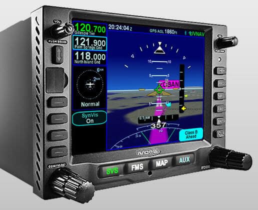
- Advanced Navigation Pages: The device features multiple navigation pages, such as the nav one page for IFR approach displays with compass arcs and digital readouts, and the map-focused nav two page. These provide pilots with vital flight information and situational awareness.
- Customization and Data Fields: Pilots can tailor data fields to display essential flight metrics like bearing, track, groundspeed, and distance. This customization ensures that pilots have the information they need at their fingertips, enhancing real-time decision-making.
- Efficient Data Access: With the GNS 530, pilots have quick access to critical data, such as airport frequencies and available approaches, directly on the device. This reduces dependence on external charts and streamlines flight planning and execution.
- Vertical Navigation and Accuracy: The unit includes vertical navigation calculations, allowing pilots to manage descents efficiently. Additionally, it provides satellite status and navigation accuracy insights, ensuring precise flight paths.
By integrating these comprehensive features, the Garmin GNS 530 transforms any flight into a more controlled and informed experience, proving itself as an essential tool in modern aviation.
Imagine navigating through a bustling airspace or a stormy night—with the GNS 530, you have a trusted co-pilot ensuring every maneuver is executed with confidence.
Understanding the Garmin Aviation GNS 530 For Pilots
- Overview of the GNS 530 – The Garmin Aviation GNS 530 is a multifunctional GPS/NAV/COMM navigator engineered for aviation excellence. It combines advanced navigation, communication, and situational awareness tools, making it a steadfast companion for pilots tackling the sky’s complexities.
- Compact and Ergonomic Design – Furthermore, despite its robust feature set, the GNS 530 boasts a compact and ergonomic design. This allows seamless installation across diverse aircraft, from nimble single-engine planes to sophisticated multi-engine jets, without compromising cockpit space or functionality.
- Intuitive User Interface – Moreover, with its user-friendly interface and intuitive controls, the GNS 530 empowers pilots to navigate its extensive features effortlessly. Clearly labeled buttons and a logical menu structure ensure quick access to critical data, even amidst the busiest flight moments.
The Garmin GNS 530 is equipped with four fundamental operating modes designed to cover various aviation needs. These modes include:
- Navigation Mode: This mode helps pilots navigate their journey by providing critical flight path information.
- Waypoint Detail Mode: Offers detailed information about waypoints, allowing for thorough flight planning and adjustments as necessary.
- Nearest Airports and Navaids Mode: Quickly access information on the closest airports and navigation aids, enhancing safety and efficiency in planning diversions or seeking alternatives.
- Auxiliary Functions Mode: This mode supports a range of additional functions that can enhance the overall flight experience.
These four modes work together to provide comprehensive support for pilots during their flights.
How to Make the GNS 530 Navigation Pages Work for You
Pilots have considerable flexibility in personalizing the information displayed on the Garmin GNS 530’s navigation pages, tailoring them to suit their flying needs. Here’s how pilots can optimize their display:
Navigation Page One
- Essential Data Display: The top spot always shows the active waypoint. Below it, pilots can choose from various data fields like bearing, track, groundspeed, and distance. This stack of information can be minimized if a larger map is necessary, but many pilots prefer keeping it visible for quick reference.
- Pilot Preferences: Beyond the essentials, pilots may customize the screen to display additional information such as aviation data and key geographical features. Choices often include the bearing and distance to waypoints, groundspeed, and estimated time of arrival. Some pilots also prefer to view the desired track for more precise navigation.
Navigation Page Two
- Mapping Features: The second navigation page primarily features a map that appeals to many pilots who enjoy visual navigation. This map can be extensively personalized concerning what gets displayed at different zoom levels. Experimentation is often required to balance detail and readability, ensuring the map isn’t cluttered with excessive information at any range.
Key Takeaway
The GNS 530 offers a customizable interface that allows pilots to select which navigation metrics are most crucial to their flight needs, enhancing situational awareness and flight efficiency. Adjusting these settings aids in creating a display that supports the pilot’s specific preferences and task requirements, whether it’s focusing on track data for efficiency or enjoying a broader visual overview with the map.
Key Features of the GNS 530
- High-Resolution Display – The GNS 530 features a vibrant, high-resolution color display delivering crisp, clear graphics. According to the FAA’s GPS navigation page, devices like this meet rigorous standards for clarity and accuracy, remaining legible in glaring sunlight or dim cockpits.
- Flight Planning Tools – Additionally, pilots can harness the GNS 530’s built-in flight planning tools to craft and adjust flight plans with ease. This includes waypoints, airways, and instrument approaches, adaptable mid-flight to meet evolving conditions or ATC directives.
- Integrated Communication Capabilities – Furthermore, the GNS 530 integrates VHF radio and transponder functionality, enabling seamless communication with air traffic control and fellow aviators—streamlining cockpit operations significantly.
- Terrain and Obstacle Awareness – For safety, the GNS 530 offers terrain and obstacle awareness, delivering visual and audible alerts about potential hazards, empowering pilots to navigate treacherous landscapes with assurance.
- The Importance of “Track” in Aerial NavigationUnderstanding the concept of “track” is crucial in aerial navigation because it represents the path to one’s destination. Track simplifies navigation by replacing complex terminologies traditionally used in flight, such as omni-bearing selectors and radials.Omni-bearing selectors, for instance, are essentially tools to choose a desired path or “track.” A radial is merely a signal that helps define this path on the ground. Additionally, a course deviation indicator provides information on how closely one is aligned with their intended trajectory.Whether you rely on digital displays or traditional pointers, knowing the track is vital. It guides the aircraft from one waypoint to another, ensuring efficient and accurate travel. If navigation systems like GPS were initially designed without the constraints of older systems, they might have consistently used the term “track,” highlighting its central role in modern navigation.
-
Features of the Map Page on the Garmin GNS 530 for Pilots
The Garmin GNS 530 offers a rich array of tools designed to enhance navigation for pilots. Central to this is the map page, which provides both practicality and an engaging experience for those who enjoy sightseeing from above.
Enjoyment Meets Utility
Map Interaction: At its core, the map page serves as a dynamic visual tool that allows pilots to identify various geographical features. Even if the automatic display doesn’t label a town, river, or lake, you can manually pinpoint names using the cursor feature. This adds an element of discovery during flight.
Data Customization: On the right side of the map, pilots can customize the stack of data fields. Typically, this includes essential information like active waypoint, bearing, track, groundspeed, and distance. For those preferring a larger map view, these fields can be minimized, though many opt to keep them visible for quick reference.
Navigation and Orientation
Cursor Functionality: The map cursor is not just for labeling geography. It can calculate bearing and distance from your current location to any point, which is particularly useful for gauging distances across large bodies of water or unfamiliar areas.
Range Selection: Pilots can adjust the map scale, selecting a range that suits their needs—from as expansive as 2,000 nautical miles, providing a broad overview, down to a precise 500 feet for detailed, up-close navigation.
Layout Details: In track-up mode, the map updates dynamically, showing a 50-mile radius from bottom to top with the aircraft symbol placed slightly above center, ensuring a forward-looking perspective. This feature helps pilots focus attention on the path ahead.
Additional Features
State Boundary Visualization: While not critical for precise navigation, the ability to display state lines answers common questions from passengers about current location, instilling confidence in the flight path.
Customization and Clarity: The system allows for pilot-specific display preferences, ensuring essential information is presented clearly without clutter. After initial setup and experimentation, pilots can streamline their display, maintaining clarity at various zoom levels.
In sum, the Garmin GNS 530 map page is designed not only for detailed navigation but also to enhance the overall flying experience with its intuitive features and customizable options.
-
Navigation Database Coverage Areas for the GNS 530
The GNS 530 navigation system offers a variety of database coverage areas to meet diverse flying needs. These areas include:
- Americas: This coverage encompasses countries in North, Central, and South America, providing extensive information across these regions.
- International: If you’re traveling beyond the Americas, the International coverage offers navigation resources across multiple continents, ensuring you have the necessary data for safe travel worldwide.
- Worldwide: For those who require comprehensive global coverage, the Worldwide option includes navigational information across all continents.
These options allow pilots to choose the database that best fits their typical flight routes, ensuring consistent and accurate navigation.
-
Every Database the GNS 530 Runs — And Why It Matters
The GNS 530 is a powerhouse of navigation technology, designed to give you a comprehensive overview of your flight environment. Here’s what it includes:
- Terrain and Navigation Databases: These built-in features provide real-time data on your current location and route, ensuring you always know where you are and where you’re going.
- Extensive Jeppesen® Database: This robust resource is loaded with essential location information. It covers everything from airport details and VORs to NDBs, intersections, and Flight Service Stations. Plus, it includes published approaches, SIDs/STARs, Special Use Airspace, and geopolitical boundaries.
- Detailed Basemap: The GNS 530 offers a rich basemap that highlights various geographical and man-made features. It showcases airports, cities, highways, railroads, rivers, lakes, coastlines, and more to provide a comprehensive view of your surroundings.
- Terrain and Obstacles Alerts: Enhanced with color coding based on terrain and U.S. Obstacles databases, the device proactively warns you of potential proximity issues, ensuring safer navigation.
- Optional Enhancements: For those seeking additional layers of security, the GNS 530 can be upgraded with WAAS navigation capabilities and an optional Class-B Terrain Awareness and Warning System (TAWS), enhancing your overall flight safety.
Therefore, This combination of rich, integrated data ensures the GNS 530 not only enhances situational awareness but also prioritizes flight safety.
Our take: The GNS 530 has been flying in GA cockpits since 1999 — and it’s still in thousands of aircraft today. If you’re flying a well-equipped 172, Archer, or Baron, odds are decent you’re looking at one right now. Knowing it cold is not optional.
 Advanced Connectivity and Integration with the GNS 530, A Comprehensive Guide to the Garmin Aviation GNS 530
 Advanced Connectivity and Integration with the GNS 530, A Comprehensive Guide to the Garmin Aviation GNS 530
- Wireless Connectivity – The GNS 530 provides wireless connectivity, allowing effortless transfers of flight plans, databases, and updates. This ensures your navigator is always equipped with the latest data, minimizing downtime and maximizing safety.
- Integration with Avionics Systems – Additionally, it integrates smoothly with avionics like autopilots, traffic alert systems, and ADS-B receivers, offering a holistic view of your flight environment for enhanced situational awareness.
- Compatibility with External Devices – Moreover, connecting tablets or smartphones to the GNS 530 unlocks additional features, such as real-time weather displays, enriching your flight with critical insights.
When the GNS 530 Goes Dark: Backup Options You Need to Know
In an avionics setup, the Garmin GNS 530 is often complemented by a suite of backup systems to ensure a pilot can maintain navigation even if the primary system encounters issues. Here’s how different devices can work alongside the GNS 530:
- NavAlert System: Positioned conveniently near critical indicators, this device is mainly used to show cross-track error and track data. It provides real-time updates on your flight path, especially relevant when anticipating wind shear.
- Secondary GPS Unit: Typically, another GPS device runs simultaneously with the GNS 530. This secondary unit mirrors the current flight plan or approach route, ready to assume primary functions if necessary.
- Older Navigation Systems: Some setups retain older navigation technology such as LORAN systems. Despite being less advanced, they serve key roles like driving navigation indicators and enhancing autopilot performance. Additionally, they offer useful data such as takeoff times and estimated arrival.
- ADFs and Other Equipment: Though not commonly used today, Automatic Direction Finders (ADFs) may still be included as a legacy system. While their functionality might be outdated, they stand ready for use if needed.
- Handheld GPS: A portable GPS unit is a reliable safety net. These devices are pre-loaded with the current flight plan and stay operational during all phases of flight, providing an immediate alternative if other systems fail.
These redundant layers enhance flight safety and give pilots peace of mind by ensuring continuous navigation and critical data access.
Applications and Benefits of the GNS 530 for Pilots
- Instrument Flight Rules (IFR) – Perfect for IFR conditions, the GNS 530’s navigation, communication, and approach capabilities guide pilots through low-visibility scenarios. As highlighted in AOPA’s review, its precision is a game-changer for IFR flights.
- Cross-Country Navigation – For long-haul journeys, the GNS 530 excels with direct-to navigation, flight plan management, and waypoint sequencing, ensuring efficient, precise travel across vast distances.
- Search and Rescue Operations – Furthermore, its pinpoint accuracy makes the GNS 530 invaluable for search and rescue, enabling swift location and aid to those in distress.
Real-World Testimonials and Reviews of the Garmin GNS 530
- Pilot Feedback – Pilots rave about the GNS 530’s reliability and ease. One shared, “During a stormy mountain crossing, its terrain alerts gave me the edge to climb safely—truly a lifesaver.” Another noted, “Its simplicity cuts through the chaos of flight.” A Comprehensive Guide to the Garmin Aviation GNS 530
- Industry Reviews – Experts agree, with NBAA’s avionics section praising its integration prowess, and publications calling it a top-tier navigator for its versatility and performance.
The Evolution of the Garmin GNS 530
now, Since its debut in the early 2000s, the Garmin GNS 530 has evolved significantly. Initially celebrated for its cutting-edge features, updates like WAAS capability have boosted its precision for LPV approaches, rivaling ILS systems in IFR scenarios.
Later, ADS-B integration enhanced traffic awareness, aligning with modern airspace mandates. Meanwhile, Garmin refined its interface, making it more intuitive—keeping the GNS 530 a leader in aviation tech. Explore more at Pilot Workshop’s training resources.
We’ll be straight with you: pilots who treat the GNS 530 as a “GPS box” are leaving a lot on the table. The flight plan editing, direct-to shortcuts, and comm management alone are worth a dedicated ground session with the manual before you fly with it.
Comparing the Garmin GNS 530 to Other Navigation Systems
While the Garmin GNS 530 shines, alternatives like the touchscreen GTN 650 offer modern flair. However, many prefer the GNS 530’s larger display and button-driven reliability.
Similarly, the Avidyne IFD540 competes with a sleek interface, yet the GNS 530’s proven track record often wins out. Ultimately, your choice hinges on cockpit needs and personal comfort.
Conclusion: The Garmin Aviation GNS 530 remains a cornerstone of aviation navigation. With its robust features, seamless integration, and pilot-centric design, it ensures safety and efficiency from takeoff to landing. Whether mastering IFR, crossing continents, or aiding rescues, this iconic tool continues to shape aviation’s future.
Comparing the Garmin GNS 530 to Legacy Avionics Systems
When evaluating how the Garmin GNS 530 stacks up against older systems like the Narco Omnigator, several key differences stand out.
Enhanced Capabilities:
- The GNS 530 is packed with advanced features that deliver more comprehensive information than older systems. It doesn’t merely replace what older avionics did; it enhances and expands the array of data available to pilots.
- Unlike the Omnigator, which provided more limited data, the 530 is designed to consolidate multiple functionalities into a single intuitive device.
User Experience and Customization:
- One of the major challenges with the GNS 530 is configuring it to suit individual preferences. However, once set up, it significantly streamlines navigation and flight management.
- This system provides a personalized flying experience, letting pilots tailor the interface to optimize how they receive and interact with information.
Technological Advancements:
- The GNS 530 offers a leap forward with its digital interface, simplifying access to a wide range of navigational aids, communication channels, and flight planning tools—all from a single unit.
- In contrast, older systems like the Omnigator required multiple pieces of equipment to deliver similar capabilities, making the flying experience more complex and less efficient.
In summary, the Garmin GNS 530 drastically improves upon older systems by integrating more data services, enhancing the user experience, and leveraging modern technology to deliver comprehensive and adaptable avionics solutions. This makes it an invaluable tool for both seasoned pilots and those transitioning from older systems.
The primary distinction between the GNS 530 and the GNS 530A lies in their communication power output. The GNS 530 comes equipped with a 10-watt communication system. Conversely, the GNS 530A model offers a more robust output of 16 watts, providing enhanced transmission capabilities for users willing to invest a little more.
GNS 530 Specifications
When evaluating the GNS 530, you’ll find that its design and functionality are compact yet robust. Here’s a detailed look at its specifications regarding dimensions, weight, and display:
Dimensions and Weight
- The GNS 530 measures 6.25 inches in width, 4.60 inches in height, and 11.0 inches in depth. That’s approximately 15.9 cm x 11.7 cm x 27.9 cm.
- It has a heft that ensures durability, weighing in at 9.5 pounds or 4.3 kilograms.
Display Features
- The GNS 530 boasts a vibrant, 8-color TFT LCD display.
- The screen dimensions are 4.0 inches wide by 3.0 inches high, translating to about 10.2 cm by 7.6 cm.
- Visual clarity is supported by a display resolution of 320 x 234 pixels, allowing for crisp visuals, crucial for navigation tasks.
With these elements, the GNS 530 combines functionality with a user-friendly interface, ensuring that you have a reliable companion for your airborne adventures.
Antenna Options for the GNS 530
When outfitting your GNS 530 unit, selecting the right antenna is crucial for optimal performance. Here’s a quick guide to the types of antennas available:
- Low-Profile Antennas
- These are ideal for streamlined installations where minimizing equipment size is a priority.
- Typically feature a flange mount design for easy attachment to the aircraft.
- Standard Profile Antennas
- Offer robust performance with a slightly larger form factor.
- Often preferred when space constraints are less of a concern and maximum signal reception is desired.
Other Options for the GNS 530
These options vary slightly in price and configuration, ensuring that you can find the one that best suits your aircraft’s needs and your budget.
Always consider compatibility and installation requirements when choosing your antenna to ensure seamless operation with the GNS 530.
however, When you purchase a GNS 530 or the GNS 530A, your package will include the following items:
- Receiver: Either the GNS 530 with a 10-watt communication capability or the GNS 530A with a 16-watt communication setup.
- Basemap: A global land basemap to enhance navigation capabilities.
- Data Storage: A Jeppesen datacard for accessing necessary navigation data.
- Antenna: A TSO GPS antenna for reliable and precise signal reception.
- Installation Accessories: An installation kit to seamlessly integrate your unit.
- Documentation: A comprehensive pilot’s guide and a quick reference guide for ease of use.
therefore, Please note that the specific contents might vary depending on the version you select. For more detailed information, it is advisable to consult your local dealer.
As an E3 Aviation member, you get access to TONS of informative aviation articles and content. Sign Up or Log In today and enjoy all of the tools, resources, product discounts, community, and entertainment that E3 Aviation Association offers.
Pilots can harness the GNS 530’s built-in flight planning tools to craft and adjust flight plans with ease. This includes waypoints, airways, and instrument approaches, adaptable mid-flight to meet evolving conditions or ATC directives.
For the frequent flyer, the GNS 530 offers up to 20 flight plan storage slots, allowing pilots to keep their most traveled routes at their fingertips. This feature is invaluable for those who prefer to have their trips pre-planned, yet it also accommodates spontaneous changes. If a pilot needs to enter a flight plan at the last minute, the intuitive interface makes it easy to do so before taxiing.
Navigation Modes and Features
The GNS 530 is equipped with four basic operating modes, covering:
- Navigation
- Waypoint Detail
- Nearest Airports and Navaids
- Auxiliary Functions
The navigation pages, particularly nav one and nav two, are crucial for flight accuracy. Nav one offers a compass arc, displaying the present ground track and a digital readout, while the bearing pointer directs pilots to the active waypoint. Aligning these indicators ensures precision in reaching your destination.
User Control and Preferences
While the auto zoom feature on the nav pages dynamically adjusts the map scale as you approach a waypoint, many pilots prefer manual control. Using the rocker switch, you can fine-tune the map range to maintain situational awareness. This flexibility underscores the GNS 530’s adaptability to pilot preferences and flying styles, making it an essential tool in the cockpit.
For more E3 Aviation resources be sure to visit: https://e3aviationassociation.com]
