
Elevating Your Flight Experience: A Comprehensive Guide to the Garmin Aviation GNS 530 | Garmin GNS 530
JOIN TODAY! | MEMBER LOGIN
In the dynamic world of aviation, the Garmin GNS 530 stands out as a beacon of precision and reliability. Additionally, this versatile GPS/NAV/COMM navigator has become an indispensable tool for pilots worldwide, offering advanced features that enhance safety and efficiency in the skies. Whether you’re a seasoned aviator or just embarking on your wings, understanding the capabilities of the Garmin GNS 530 can elevate your flight experience to new heights.
Imagine navigating through a bustling airspace or a stormy night—with the GNS 530, you have a trusted co-pilot ensuring every maneuver is executed with confidence.
Understanding the Garmin Aviation GNS 530 For Pilots
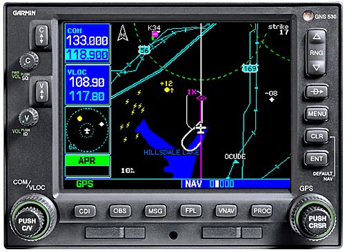
- Overview of the GNS 530 – The Garmin Aviation GNS 530 is a multifunctional GPS/NAV/COMM navigator engineered for aviation excellence. It combines advanced navigation, communication, and situational awareness tools, making it a steadfast companion for pilots tackling the sky’s complexities.
- Compact and Ergonomic Design – Furthermore, despite its robust feature set, the GNS 530 boasts a compact and ergonomic design. This allows seamless installation across diverse aircraft, from nimble single-engine planes to sophisticated multi-engine jets, without compromising cockpit space or functionality.
- Intuitive User Interface – Moreover, with its user-friendly interface and intuitive controls, the GNS 530 empowers pilots to navigate its extensive features effortlessly. Clearly labeled buttons and a logical menu structure ensure quick access to critical data, even amidst the busiest flight moments.
Key Features of the GNS 530
- High-Resolution Display – The GNS 530 features a vibrant, high-resolution color display delivering crisp, clear graphics. According to the FAA’s GPS navigation page, devices like this meet rigorous standards for clarity and accuracy, remaining legible in glaring sunlight or dim cockpits.
- Flight Planning Tools – Additionally, pilots can harness the GNS 530’s built-in flight planning tools to craft and adjust flight plans with ease. This includes waypoints, airways, and instrument approaches, adaptable mid-flight to meet evolving conditions or ATC directives.
- Integrated Communication Capabilities – Furthermore, the GNS 530 integrates VHF radio and transponder functionality, enabling seamless communication with air traffic control and fellow aviators—streamlining cockpit operations significantly.
- Terrain and Obstacle Awareness – For safety, the GNS 530 offers terrain and obstacle awareness, delivering visual and audible alerts about potential hazards, empowering pilots to navigate treacherous landscapes with assurance.
Navigation Database Coverage Areas for the GNS 530
The GNS 530 navigation system offers a variety of database coverage areas to meet diverse flying needs. These areas include:
- Americas: This coverage encompasses countries in North, Central, and South America, providing extensive information across these regions.
- International: If you’re traveling beyond the Americas, the International coverage offers navigation resources across multiple continents, ensuring you have the necessary data for safe travel worldwide.
- Worldwide: For those who require comprehensive global coverage, the Worldwide option includes navigational information across all continents.
These options allow pilots to choose the database that best fits their typical flight routes, ensuring consistent and accurate navigation.
What Databases and Navigation Information Are Integrated into the GNS 530?
The GNS 530 is a powerhouse of navigation technology, designed to give you a comprehensive overview of your flight environment. Here’s what it includes:
- Terrain and Navigation Databases: These built-in features provide real-time data on your current location and route, ensuring you always know where you are and where you’re going.
- Extensive Jeppesen® Database: This robust resource is loaded with essential location information. It covers everything from airport details and VORs to NDBs, intersections, and Flight Service Stations. Plus, it includes published approaches, SIDs/STARs, Special Use Airspace, and geopolitical boundaries.
- Detailed Basemap: The GNS 530 offers a rich basemap that highlights various geographical and man-made features. It showcases airports, cities, highways, railroads, rivers, lakes, coastlines, and more to provide a comprehensive view of your surroundings.
- Terrain and Obstacles Alerts: Enhanced with color coding based on terrain and U.S. Obstacles databases, the device proactively warns you of potential proximity issues, ensuring safer navigation.
- Optional Enhancements: For those seeking additional layers of security, the GNS 530 can be upgraded with WAAS navigation capabilities and an optional Class-B Terrain Awareness and Warning System (TAWS), enhancing your overall flight safety.
Therefore, This combination of rich, integrated data ensures the GNS 530 not only enhances situational awareness but also prioritizes flight safety.
Advanced Connectivity and Integration with the GNS 530
- Wireless Connectivity – The GNS 530 provides wireless connectivity, allowing effortless transfers of flight plans, databases, and updates. This ensures your navigator is always equipped with the latest data, minimizing downtime and maximizing safety.
- Integration with Avionics Systems – Additionally, it integrates smoothly with avionics like autopilots, traffic alert systems, and ADS-B receivers, offering a holistic view of your flight environment for enhanced situational awareness.
- Compatibility with External Devices – Moreover, connecting tablets or smartphones to the GNS 530 unlocks additional features, such as real-time weather displays, enriching your flight with critical insights.
Applications and Benefits of the GNS 530 for Pilots
- Instrument Flight Rules (IFR) – Perfect for IFR conditions, the GNS 530’s navigation, communication, and approach capabilities guide pilots through low-visibility scenarios. As highlighted in AOPA’s review, its precision is a game-changer for IFR flights.
- Cross-Country Navigation – For long-haul journeys, the GNS 530 excels with direct-to navigation, flight plan management, and waypoint sequencing, ensuring efficient, precise travel across vast distances.
- Search and Rescue Operations – Furthermore, its pinpoint accuracy makes the GNS 530 invaluable for search and rescue, enabling swift location and aid to those in distress.
Real-World Testimonials and Reviews of the Garmin GNS 530
- Pilot Feedback – Pilots rave about the GNS 530’s reliability and ease. One shared, “During a stormy mountain crossing, its terrain alerts gave me the edge to climb safely—truly a lifesaver.” Another noted, “Its simplicity cuts through the chaos of flight.”
- Industry Reviews – Experts agree, with NBAA’s avionics section praising its integration prowess, and publications calling it a top-tier navigator for its versatility and performance.
The Evolution of the Garmin GNS 530
now, Since its debut in the early 2000s, the Garmin GNS 530 has evolved significantly. Initially celebrated for its cutting-edge features, updates like WAAS capability have boosted its precision for LPV approaches, rivaling ILS systems in IFR scenarios.
Later, ADS-B integration enhanced traffic awareness, aligning with modern airspace mandates. Meanwhile, Garmin refined its interface, making it more intuitive—keeping the GNS 530 a leader in aviation tech. Explore more at Pilot Workshop’s training resources.
Comparing the Garmin GNS 530 to Other Navigation Systems
While the Garmin GNS 530 shines, alternatives like the touchscreen GTN 650 offer modern flair. However, many prefer the GNS 530’s larger display and button-driven reliability—details explored in Boldmethod’s comparison.
Similarly, the Avidyne IFD540 competes with a sleek interface, yet the GNS 530’s proven track record often wins out. Ultimately, your choice hinges on cockpit needs and personal comfort.
Conclusion: The Garmin Aviation GNS 530 remains a cornerstone of aviation navigation. With its robust features, seamless integration, and pilot-centric design, it ensures safety and efficiency from takeoff to landing. Whether mastering IFR, crossing continents, or aiding rescues, this iconic tool continues to shape aviation’s future.
The primary distinction between the GNS 530 and the GNS 530A lies in their communication power output. The GNS 530 comes equipped with a 10-watt communication system. Conversely, the GNS 530A model offers a more robust output of 16 watts, providing enhanced transmission capabilities for users willing to invest a little more.
GNS 530 Specifications
When evaluating the GNS 530, you’ll find that its design and functionality are compact yet robust. Here’s a detailed look at its specifications regarding dimensions, weight, and display:
Dimensions and Weight
- The GNS 530 measures 6.25 inches in width, 4.60 inches in height, and 11.0 inches in depth. That’s approximately 15.9 cm x 11.7 cm x 27.9 cm.
- It has a heft that ensures durability, weighing in at 9.5 pounds or 4.3 kilograms.
Display Features
- The GNS 530 boasts a vibrant, 8-color TFT LCD display.
- The screen dimensions are 4.0 inches wide by 3.0 inches high, translating to about 10.2 cm by 7.6 cm.
- Visual clarity is supported by a display resolution of 320 x 234 pixels, allowing for crisp visuals, crucial for navigation tasks.
With these elements, the GNS 530 combines functionality with a user-friendly interface, ensuring that you have a reliable companion for your airborne adventures.
Antenna Options for the GNS 530
When outfitting your GNS 530 unit, selecting the right antenna is crucial for optimal performance. Here’s a quick guide to the types of antennas available:
- Low-Profile Antennas
- These are ideal for streamlined installations where minimizing equipment size is a priority.
- Typically feature a flange mount design for easy attachment to the aircraft.
- Standard Profile Antennas
- Offer robust performance with a slightly larger form factor.
- Often preferred when space constraints are less of a concern and maximum signal reception is desired.
Other Options for the GNS 530
These options vary slightly in price and configuration, ensuring that you can find the one that best suits your aircraft’s needs and your budget.
Always consider compatibility and installation requirements when choosing your antenna to ensure seamless operation with the GNS 530.
however, When you purchase a GNS 530 or the GNS 530A, your package will include the following items:
- Receiver: Either the GNS 530 with a 10-watt communication capability or the GNS 530A with a 16-watt communication setup.
- Basemap: A global land basemap to enhance navigation capabilities.
- Data Storage: A Jeppesen datacard for accessing necessary navigation data.
- Antenna: A TSO GPS antenna for reliable and precise signal reception.
- Installation Accessories: An installation kit to seamlessly integrate your unit.
- Documentation: A comprehensive pilot’s guide and a quick reference guide for ease of use.
therefore, Please note that the specific contents might vary depending on the version you select. For more detailed information, it is advisable to consult your local dealer.
As an E3 Aviation member, you get access to TONS of informative aviation articles and content. Sign Up or Log In today and enjoy all of the tools, resources, product discounts, community, and entertainment that E3 Aviation Association offers.
For more E3 Aviation resources be sure to visit: https://e3aviationassociation.com
Garmin GNS 530, aviation navigation, GPS navigator, pilot tools, flight safety, Garmin aviation, navigation equipment, Garmin GNS 530 features, Garmin GNS 530 reviews, Garmin GNS 530 training